

The Health and Demographic Surveillance System (HDSS) of CHAMPS, Bangladesh
Baliakandi upazila is a plain land and agriculture is the main occupation. There is a 50-bed health complex (Baliakandi UHC) serving the population; Faridpur Medical College Hospital and Zahid Memorial Child Hospital are the referral-level tertiary hospitals, 42 km away.
DSS provides data on each individual in the geographically defined area: name, date of birth, sex, relation to household head, marital status, birth, death and migration. It also collects household socio-economic data at baseline, education and occupation of household head; reproductive histories of ever-married women are collected, including pregnancies, ANC visits, outcome, postnatal visits and geographic location of households. Every under-5 child receives a child card with a bar code. DSS collects additional data on the date of death, place of death, and place of burial for every death; every pregnant woman is tracked for pregnancy outcome, delivery attendant and place of delivery.
Below are some population statistics based on the most recent data, from 2020:
The Mapping team used GPS to collect the location of all houses, public and private health facilities, educational institutions, etc. and some basic information about these facilities. The team also collects the location of every road by an auto tracking system of GPS.
 |
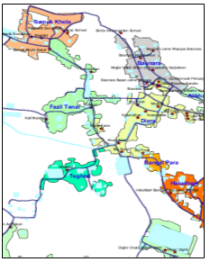 |
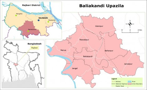
Figure: Map of the demographic surveillance area |
Digital map of a village |
Thirty data collectors are engaged in data collection to update demographic events for every individual and for reproductive events of each ever-married woman of reproductive age using tablets. The area is divided into 30 clusters, each with around 7,350 population, one Data Collector (DC) covers each cluster. Each cluster is divided into forty (40) blocks, with around 184 people in around 45 households (Fig:2); using the prepared GIS based maps, the DC visits one block per day, so that all blocks are covered in 2 months’ time.
Six immediate field supervisors and two second line supervisors supervise and monitor the activities. Four additional data collectors record pregnancy outcomes of every pregnant women by visiting them around their expected date of delivery.
*Last Updated on 3rd August, 2025